Back Kabupatén Bélu BAN Kabupatèn Bélu BEW Kabupaten Belu CEB Belu (Regierungsbezirk) German Kabupaten de Belu French Kabupaten Belu ID Reggenza di Belu Italian Kabupatèn Belu JV Kabupaten Belu Malay Belu (regentschap) Dutch
Belu Regency
Kabupaten Belu Rai Belu | |
|---|---|
| Nickname: Belu | |
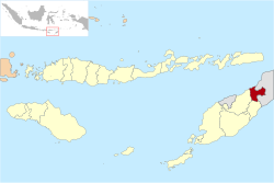
 Location within East Nusa Tenggara | |
| Coordinates: 9°20′45″S 124°57′2″E / 9.34583°S 124.95056°E | |
| Country | |
| Region | Lesser Sunda Islands |
| Province | |
| Settled | 20 December 1956 |
| Capital | Atambua |
| Government | |
| • Regent | Willy Lay |
| • Vice Regent | J. T. Ose Luan |
| Area | |
| • Total | 496.12 sq mi (1,284.94 km2) |
| Elevation | 1,230 ft (375 m) |
| Population (mid 2023 estimate)[1] | |
| • Total | 231,008 |
| • Density | 470/sq mi (180/km2) |
| Time zone | UTC+8 (ICST) |
| Postcodes | 856xx, 857xx |
| Area code | (+62) 389 |
| Religion | Christianity 95.45% — Catholic 88.39% — Protestant 7.10% Islam 4.30% Hindu 0.19% Buddhism 0.02%[2] |
| Website | belukab |
Belu Regency is a regency in East Nusa Tenggara province of Indonesia. Situated on the north side of Timor island, it adjoins the North Central Timor Regency to the west and the separate nation of East Timor to the east. Established on 20 December 1958,[3] Belu Regency has its seat (capital) in the large town of Atambua.
- ^ Badan Pusat Statistik, Jakarta, 28 February 2024, Kabupaten Belu Dalam Angka 2024 (Katalog-BPS 1102001.5304)
- ^ "Kabupaten Belu Dalam Angka 2019". www.belukab.bps.go.id (in Indonesian). Retrieved 13 February 2020.
- ^ Government of Indonesia (9 August 1958), Establishment of the Second-level Administrative Regions under the First-level Administrative Region of Bali, West Nusa Tenggara and East Nusa Tenggara (in Indonesian ed.), Indonesia Ministry of Law and Justice, UU No. 69/1958, retrieved 24 August 2007[permanent dead link]


